

Earthquake: Sparta, NC, 5.1M, 3.1km depth
For immediate release ‐ August 10, 2020
Contact: Chris Tacker, christopher.tacker@naturalsciences.org. Images available upon request
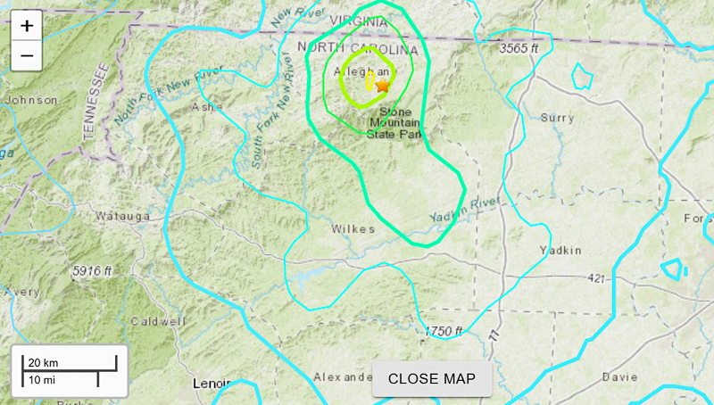 Epicenter map courtesy United States Geological Survey.
Anyone out of bed on this Sunday morning at 8:00 a.m. probably felt an earthquake. It was located in the mountains, near Sparta, NC. It was fairly shallow, about 2.3 miles down.
You can help out the United States Geological Survey with their Did You Feel It? program. This citizen science program helps with models of seismic wave propagation through the upper crust, and prediction of the effects of future earthquakes. It will have input from people from all over three states.
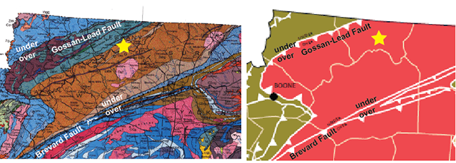 Geologic maps of northwestern North Carolina, with the epicenter of the Sparta earthquake as a yellow star. On the left is the region from the 1985 Geologic Map of North Carolina, courtesy of the North Carolina Geological Survey. On the right is the same region, simplified to show the bounding faults. Southeast of the Gossan-Lead Fault to the Brevard Fault is the thrust sheet under discussion.
The epicenter was in part of the mountains we call the Eastern Blue Ridge in the most generic models. The geology of this part of the mountains is complicated, so we need some boundaries. You can see in the figure above that it can be simplified.
To the southeast is the Brevard Zone Fault, which is a major geologic feature, running from north of Atlanta, through Brevard (duh, geologists aren’t real creative with names). It crosses I-40 at Old Fort, right at the base of the big grade up the mountain to Black Mountain and Swannanoa. It runs through Marion and up to North Wilkesboro, where it splinters into several faults. When you travel 421 from Winston-Salem to Boone, you crest a hill east of Wilkesboro and have a splendid view of these faults in the Yadkin River valley.
To the southwest and northwest, the Eastern Blue Ridge is bounded by the Gossan-Lead Fault, as it’s known in Virginia. It has a few other names as it winds to the southwest. The Gossan-Lead Fault dives beneath this package of rock and forms the lower, bottom, border.
 An unfortunate example of thrust faulting, with the fault marked, the motion indicated, and flags on the upper plate. Please contact me for proper attribution.
It’s a thrust sheet- the upper layer of a package of crust that was pushed from east to west over the edge of North America. It ramped up onto the continent like a tractor-trailer rig hitting a small car. Several different collisions created the Appalachians, and thrust faults are the result.
This is a very simplified version of thrust faulting. It would take a lot more work to identify the actual fault, but in that region, it’s an old thrust fault.
Don’t panic.
This isn’t evidence of active faulting. Faults are the scars of plate tectonics, lacing the geologic maps of eastern North America from Alabama to Canada. I’ve described North Carolina’s faults as a creaky old house. Sometimes there’s a little motion on one to relieve residual stress. Creak. Crack. Earthquake. It’s fair to say that the stress is transferred to us.
The good people at the Incorporated Research Institutions for Seismology (IRIS) have provided a Teachable Moments PowerPoint presentation about the Sparta, NC earthquake. It combines excellent science with good graphics. You can also find other goodies if you explore their site.